• You will need to login or register before you can post a message. If you already have an Agriville account login by clicking the login icon on the top right corner of the page. If you are a new user you will need to Register.

Announcement

Collapse
No announcement yet.

Dumb Question Canadian Land

Collapse
X
Collapse
 
  • Filter
  • Time
  • Show
Clear All
new posts

    Dumb Question Canadian Land

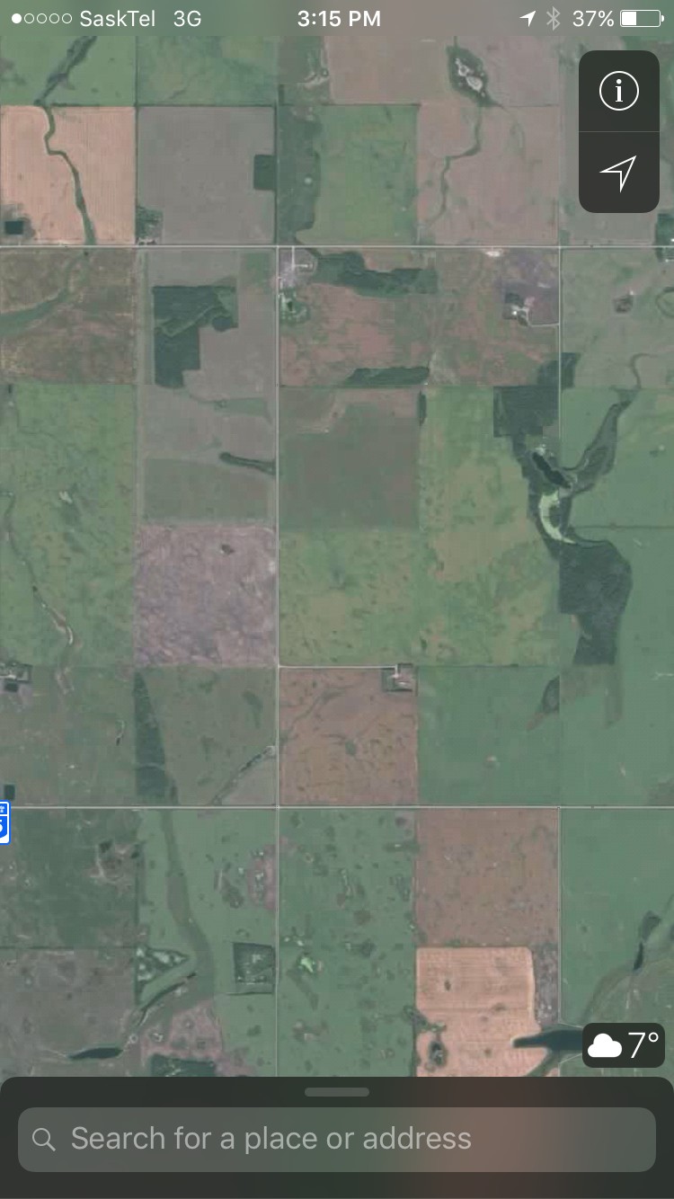
    You guys speak of quarter which i presume is a quarter section of a square mile?
    So are all your farms square?
    Presumes creeks river roads etc make that impractical at times?
    #2
    Fields are square, quarter sections 1/2mile by 1/2 mile.

    Comment


      #3
      https://en.wikipedia.org/wiki/Dominion_Land_Survey

      Comment


        #4
        so guys who graze cattle then fence in fields of pasture i presume and in mountain grazing country does the quarter sectioning still happen?

        Comment


          #5
          Malle, what size are your fields in Oz?

          Comment


            #6
            Hi when I looked a farms in Canada I was stunned by the need for correction lines due to the curvature of the earth, quarters on these lines are not 160 acres.

            This link explains it better

            http://www.alsa.ab.ca/PublicInformation/AlbertasTownshipSystem.aspx

            Comment


              #7
              Originally posted by malleefarmer View Post
              You guys speak of quarter which i presume is a quarter section of a square mile?
              So are all your farms square?
              Presumes creeks river roads etc make that impractical at times?
              Depends where you are. Quebec is mostly laid out in long, skinny 100 acre farms. Around here they mostly made square 100 acre farms

              Comment


                #8
                Originally posted by dalek View Post
                Depends where you are. Quebec is mostly laid out in long, skinny 100 acre farms. Around here they mostly made square 100 acre farms
                Wasn't the length of those Quebec farms determined by the length a team of oxen could plow before they needed a rest, and they measure in arpents? The skinny shape gave every Habitant river access.

                Hard to believe when the west was initially settled the idea was for a farm on every quarter. That didn't last long before half section farms were the norm around here. The worst was the poor lemmings they tried sticking in the bush rocks and sand of NW sask. One area where I pasture close had 100 homesteads in the 1930's. Lots of dust bowlers escaping drought only to all succumb to starvation, freezing, or suicide. My grandpa told me some grizzly stories. Not one person lives there today. I should write a book before all the old people die. It would make a good read.

                Comment


                  #9
                  There's a few areas in western Canada that have river lots similar to the ones in Quebec. In my experience they are areas that were settled very early, typically by Metis.

                  Comment


                    #10
                    I own two riverlots, nothing to do with metis, i was told two places in alberta have these. Here we also have settlement lots, land divided up to settlers who were here before the surveyors and around a old trading post, was metis there at the time.

                    Comment


                      #11
                      Mallee where we are at in Alberta it is pretty much all square quarters other than a few highways in the wrong spot that changes some. The 160 acres per quarter is approx. They are often 158 or 159 due to the roads often take a bit more than they were supposed to. Have seen a couple titles over the 160 acres also but not sure why. In mixed farming areas lots of fencing and lots of irregular pieces unsuitable for cropland. Better grain land areas lots of fences and shelter belts have been removed in recent years to make larger fields. About 40 miles west you start getting into the forestry reserves. Looking at aerial views or MD maps you can still see lots of quarter lines. The grazing leases out there are mostly determined by nature with mountain ridges and waterways but there are still some fences. No real property lines as is mostly crown land. Lots of the forestry area has cut lines in a grid pattern for access to oil and gas and logging. It is really amazing the planning and measuring they did with the layout at time of settlement without the technology we have now.

                      Comment


                        #12
                        the biggest field on our farm is 182 hectares

                        Comment


                          #13
                          Where we are in eastern Sask under the original standard survey system, land is in two one mile square section blocks not separated by road allowances making 1280 acres. A little farther to east of second meridian and in much of Manitoba, road allowances run one mile apart each direction making each section separate.
                          In practice, many road allowances are farmed across making it difficult to tell where largest fields are. On own farm, could have over two sections in one field but water runways make it impractical most years.

                          Comment

                          • Reply to this Thread
                          • Return to Topic List
                          Working...