• You will need to login or register before you can post a message. If you already have an Agriville account login by clicking the login icon on the top right corner of the page. If you are a new user you will need to Register.

Announcement

Collapse
No announcement yet.

Got sent this cool river runner site

Collapse
X
Collapse
 
  • Filter
  • Time
  • Show
Clear All
new posts

    #13
    I live in central Alberta burnt but I do know the milk river ends up in the Missouri River while I think it’s the saint Mary heads north east to the south Saskatchewan river.

    Comment


      #14
      Originally posted by TSIPP View Post
      Some watershed maps of this area show all my water flowing north and some maps show some north and some flows south, realistically it doesn’t flow very far in any direction I’d say most of this area is in a dead zone.
      I was looking at a map of the Saskatchewan river watershed. It shows a big gap between the north and south sask rivers somewhat centered on the Sask AB border and straight west of Saskatoon.

      So if that areas isn't part of the watershed, and it can't go anywhere else, being surrounded by the Sask river watershed, is it just a giant pothole that doesn't drain? Destined to become an inland sea if it ever rains there?

      Comment


        #15
        Battle and red deer river and their tributaries end up in north and south Saskatchewan rivers.

        Comment


          #16
          so if were landscaping that water goes Total Length: 2389 km till it gets to Hudson bay. Very cool and Big Quill is just a pothole

          Comment


            #17
            Is that site higher resolution than the regular maps?

            Can see the cow paths in my pasture and I think the cows walking on them.

            Comment


              #18
              Originally posted by AlbertaFarmer5 View Post
              I was looking at a map of the Saskatchewan river watershed. It shows a big gap between the north and south sask rivers somewhat centered on the Sask AB border and straight west of Saskatoon.

              So if that areas isn't part of the watershed, and it can't go anywhere else, being surrounded by the Sask river watershed, is it just a giant pothole that doesn't drain? Destined to become an inland sea if it ever rains there?
              https://upload.wikimedia.org/wikiped..._basin_map.png
              I’m sure that during a major flood in biblical proportions that would be an inland sea. Kinda like this area south of Moose Jaw.

              Comment


                #19
                Originally posted by burnt View Post
                Really cool! Thank you for posting that.

                Reminds me of when I was helping with harvest in Alberta in 78. Can't remember place names very well, but near Stirling. We drove a piece west, I think, and was swathing barley on what the boss called "The Ridge", just a twisting mass of hills and hollows.

                He said that at that point of the province, the watershed split and ran either west or north, I think, being the Continental Divide. I may be mistaken on the details but that's what I recall.
                Somewhere between the milk river and old man river must be a continental divide, it might not be really noticeable but must be some kind of higher elevation between the two rivers.

                Comment


                  #20
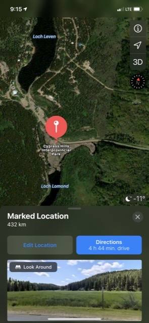
                  This is another divide , one of my favourite spots
                  Loch Leven water ends up in Hudson Bay via the South Sask river
                  Loch Lomond water ends up in the Gulf of Mexico

                  Comment

                  • Reply to this Thread
                  • Return to Topic List
                  Working...